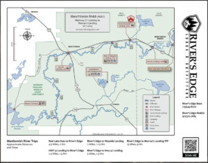
Manitowish River Trail Hwy. 51 Bridge into Turtle-Flambeau Flowage.
Total: 20 miles.
Rating: Novice.
Named for the "manitous" or spirit people of the Ojibwa, the Manitowish is a clean sandy bottomed river with a steady current.
This route is a continuation of the popular Manitowish trip that begins at High Lake (Vilas County) at the river's origin on Co. B east of Presque Isle.
As it enters Iron County, west of the village of Manitowish Waters, it leaves the populated Manitowish Chain of Lakes and flows through quiet pine-studded uplands and wildlife-rich marshes. During normal water levels there should be no portages.
There are several state-owned rustic campsites along the route. Most do not have water. Be prepared to bring your own if you plan to camp. A variety of trips of different lengths may be made depending on the choice of put-in.
- The trip may be started below the Rest Lake Dam in Manitowish Waters or downstream at the Hwy. 51 bridge.
Downstream from the Hwy. 51 bridge, the river makes a wide "S" curve and bends into a short, but fun Class I rapids. It should pose no problems. There is a good fishing hole along the high sand banks at the end of the bend.
The river widens briefly into Sturgeon Lake. After this point, no other development will be found along the route except for rustic campsites and waysides.
- The old bridge abutments at the State Wayside on Hwy. 51 mark this as a potential take-out or put-in. Water and toilet facilities are available here, but no camping is permitted. It is roughly a 1 1/2-2 hour paddle from the Hwy. 51 put-in to this point.
The character of the river changes now as it enters a large marshy area. Currents remain good and some interesting side trips can be made up the backwater sloughs to investigate the many "pine islands" that dot the river's banks.
- A popular take-out is at the town of Manitowish. The take-out is located on the east (right) bank of the river, just before it passes under an old railroad trestle and the Hwy. 47 bridge. Paddle up a small slough to get to the take-out.
Paddling time for the Hwy. 51 bridge to Manitowish is approximately 3 hours and makes a nice half-day trip. Limited supplies are available at Manitowish.
Downstream, the river continues through a large marsh, its course bending south.
- Past Manitowish, there are no take-outs until Murray's Landing in the Flambeau Flowage. Paddling time from Manitowish to Murray's Landing is approximately 5 hours.
The newly-designated Manitowish River Wilderness Area lies to the east of the river's edge and Hwy. 47. This is a great area to see waterfowl!
There are 4 rustic state-owned campsites along this section. Watch for the convergence of the Bear River from the left. A favorite camping and fishing spot is at the confluence.
Together the waters of the Bear and the Manitowish Rivers create the mighty North Fork of the Flambeau River. The river now widens, meanders and marshy islands mark the entrance into the great 19,000 acre Turtle-Flambeau Flowage.
- It is approximately a 2-hour paddle from the Bear River to the Murray's Landing take-out.
Murray's Landing is located about 2 miles into the main body of the Flowage. This is a well-marked public boat landing located on the right (north) shore of the river where it narrows to a 100-foot width before entering the main body of the flowage. Murray's Landing is connected by Murray's Landing Road to Hwy. 51, 1/2 mile west of Manitowish. Supplies are available in Manitowish or Mercer.
This trip may be extended by paddling through the Flowage to Turtle Dam, a distance of approximately 9 1/2 miles. (see river route #2 for information on the Turtle-Flambeau Flowage).
For Canoe/Kayak guide maps request our "Iron County Sportsman's & Recreation Map" here: Contact Us
