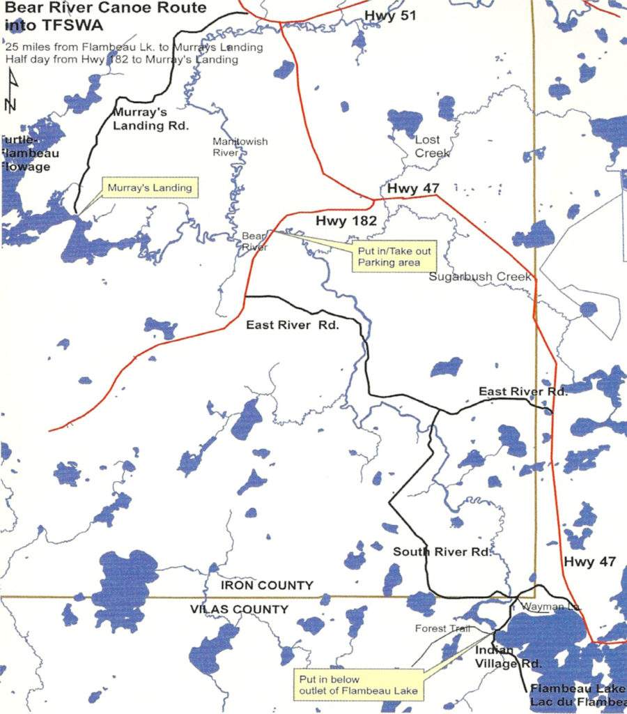
Bear River Trail Flambeau Lake to Murray's Landing (Turtle-Flambeau Flowage).
Total: 25 miles
Rating: Novice
Bear River Canoe Trail in Iron County, Wisconsin
This trip is tranquil and unspoiled by development. There is always an opportunity to see wildlife. Fishing is usually good.
Only one low hazard rapids, better described as a "riffle", will be encountered at the second bridge crossing. A good portion of this route passes through the historic Lac du Flambeau Indian Reservation.
- The usual put-in is below the outlet of Flambeau Lake. This makes a 25-mile paddle to the Murray's Landing take-out.
- Other put-in points can be made at either of the two town road bridges or at the State Hwy. 182 bridge. Putting in at the Hwy. 182 bridge makes a fine half-day paddle to Murray's Landing.
The full trip starts at Flambeau Lake, southwest of the town of Lac du Flambeau.
- The put-in is below Flambeau Dam off the public road.
The first 4 miles of the trip is narrow and full of oxbows as the river bends through a great marsh. It soon widens and the current becomes faster. A creek entering here is a favorite for ducks and geese. The river becomes wider and deeper with fewer bends past this point. The river continues through another large marsh, assuming an almost "bottom land" character before it crosses the third bridge at Hwy. 182.
- There are no take-outs from this point down stream to Murray's Landing.
Look for the Manitowish River joining the Bear. From this point on, the two rivers are called the Flambeau River-North Fork. A favorite campsite is at the confluence of the rivers. Good walleye fishing can be found there too.
From the confluence to Murray's Landing in the Turtle-Flambeau Flowage requires about 2 hours of paddling. Murray's Landing is a well-marked public boat landing on the right shore where the river narrows to a 100-yard width before entering the main body of the Flowage.
Murray's Landing is connected by Murray's Landing Road to Hwy. 51, 1/2 mile west of the town of Manitowish. Supplies are available in Mercer or Manitowish.
For Canoe/Kayak guide maps request our "Iron County Sportsman's & Recreation Map" here: Contact Us
